Wednesday, August 17, 2005
I can see your house from up here
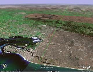
 I know I promised Tom to explain why it will take so long for Messenger to get to Mercury, but Margaret provided these marvelous links to the NASA satellite earth station in Carnarvon, WA and the big dish at Tidbinbilla. These above pages to link to Google Maps, which provides high resolution satellite Images as maps. But now there is Google Earth. Google Earth also provides high resolution satellite imagery, but with a 3D interface, the ability to add overlays of roads and services, provide bookmarks and make tours. It's phenomenal, and there is even a site Google Earth Hacks, devoted to producing innovative ways to use Google Earth. Mostly geography applications at the moment, although there is a live storm tracker. The down side is that you require at least Windows 2000 or higher, 200 Mb RAM and a broadband connection.
 It hasn't taken the astronomical community long to find novel uses for Google Earth, the RANZ Occultation section are putting out occultation paths in Google Earth KML format (basically a version of XML). This is seriously helpful. The occultation service puts out good maps, but with the Zoom function in Google Earth you can really be sure of where the best viewing places are in relation to yourself. This can be applied to other astronomical data as well, ISS transit visibility, Southern limits of observations of stars, current sun position and day/night terminator and so on.
You can also set up maps of Star Camps, public dark sky sites and do tours of famous astronomical sites, such as Tidbinbilla. Here is a link to my first KML file that hovers you above Tidbinbilla (the source of the above image). When I work out how to make tours, it will take you to Parkes, Canarvon, Mt Stromlo, Siding Springs and Woomera (and maybe even bounce over to Manchester to visit the Woomera dish there). Yes, I know I'm also writing these celestia files as well, so it won't happen Real Soon Now, but an astrotour is on its way (any requests from you folks for a world wide astrotour?).
Of course, there are downsides to the high resolution satellite maps, anyone armed with your address (or precise Latitude Longitude) can see your house and backyard via Google. This may become a new form of vouyerism. Also, there have been calls to censor Google Maps in sensitive areas that might be terrorist targets.
I can see that the arguments will rage back and forth, but in the meantime, enjoy Google Earth and its uses for astronomy. Google even does Latitude Longitude searches. Type 34d 48' 58.6"S, 138d 29' 59.86"E into the search box. You won't see me waving from my backyard though, unlike every other part of Adelaide, we are in low resolution, and you can barely see the streets. Could be just a bad satellite pass, couldn't have anything to do with the Naval Facility up the road.
Comments:
<< Home
Great story on Google earth Ian,
I have it installed and will look fro some of those add on's
Here is a link to my Blog for our club in Arnhem land
http://ntstargazer.blogspot.com/
Cheers
Ian
I have it installed and will look fro some of those add on's
Here is a link to my Blog for our club in Arnhem land
http://ntstargazer.blogspot.com/
Cheers
Ian
G'Day Ian
Hope you find Google Earth as fascinating and helpful as I have.
I've added you to the blog roll, and I'll pop you into Southern Skywatch when I next update it
Post a Comment
Hope you find Google Earth as fascinating and helpful as I have.
I've added you to the blog roll, and I'll pop you into Southern Skywatch when I next update it
<< Home


 Click to read about or order
 Click to read about or order
 Click to read about or order
 Click to read about or order


